Jump to content
Main menu
Main menu
move to sidebar
hide
Navigate
Main page
Welcome
Community portal
Village pump
Help center
Participate
Upload file
Recent changes
Latest files
Random file
Contact us
Special pages
In Wikipedia
Add links
Search
Search
English
Appearance
Donate
Create account
Log in
Personal tools
Donate
Create account
Log in
Category
:
Maps of Belgium in the 8th century
Help
Category
Discussion
English
Read
Edit
View history
Tools
Tools
move to sidebar
hide
Actions
Read
Edit
View history
General
What links here
Related changes
Permanent link
Page information
Get shortened URL
Download QR code
Print/export
Create a book
Download as PDF
Printable version
In other projects
Appearance
move to sidebar
hide
From Wikimedia Commons, the free media repository
English:
Belgique / België (Belgium)
This category is directed to maps showing all or substantially all of the
territory
of modern-day
Belgium
- as the lands were in the 8th century (701-800 CE)
See also categories:
Belgium in the 8th century
and
History of Belgium
.
Maps of the history of Belgium
:
(
BCE
)
(
CE
)
7th century
·
8th century
·
9th century
·
10th century
·
11th century
·
12th century
·
13th century
·
14th century
·
15th century
·
16th century
·
17th century
·
18th century
·
19th century
·
20th century
·
Countries of Europe
:
Belgium
·
Bulgaria
·
France
‡
·
Germany
·
Greece
·
Ireland
·
Italy
·
Luxembourg
·
Netherlands
‡
Nations of the United Kingdom
:
England
·
Scotland
·
Wales
Media in category "Maps of Belgium in the 8th century"
The following 5 files are in this category, out of 5 total.
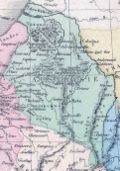
Austrasie752.jpg
484 × 689; 78 KB
C. 752 German Provinces.jpg
922 × 1,095; 767 KB
144 of 'Histoire de la Belgique ... Troisième edition, entièrement refondue et ... augmentée, etc' (11042533084).jpg
2,656 × 1,731; 720 KB
Austrasie - btv1b8495009t.jpg
6,448 × 8,122; 7.29 MB
Image taken from page 41 of 'Histoire populaire des Belges et de leurs institutions ... jusqu'en 1880, etc' (11150549814).jpg
2,705 × 1,806; 886 KB
Categories
:
Maps of Belgium by century
Maps of the history of Belgium by century
Maps of the Benelux
Maps of the Low Countries in the 8th century
Maps of Europe in the 8th century
Belgium in the 8th century
Search
Search
Category
:
Maps of Belgium in the 8th century
Add topic


.svg/40px-Flag_of_Belgium_(civil).svg.png) Belgium - as the lands were in the 8th century (701-800 CE)
Belgium - as the lands were in the 8th century (701-800 CE)
 Austrasie752.jpg 484 × 689; 78 KB
 C. 752 German Provinces.jpg 922 × 1,095; 767 KB
.jpg/120px-144_of_%27Histoire_de_la_Belgique_..._Troisième_edition%2C_entièrement_refondue_et_..._augmentée%2C_etc%27_(11042533084).jpg)
 Austrasie - btv1b8495009t.jpg 6,448 × 8,122; 7.29 MB
.jpg/120px-Image_taken_from_page_41_of_%27Histoire_populaire_des_Belges_et_de_leurs_institutions_..._jusqu%27en_1880%2C_etc%27_(11150549814).jpg)


.jpg)

.jpg)